

CHAPTER 3 ELECTORAL POLITICS
April 13, 2025CHAPTER 5 Natural Vegetation and Wildlife
April 13, 2025Q1. Choose the correct answer from the four alternatives given below.
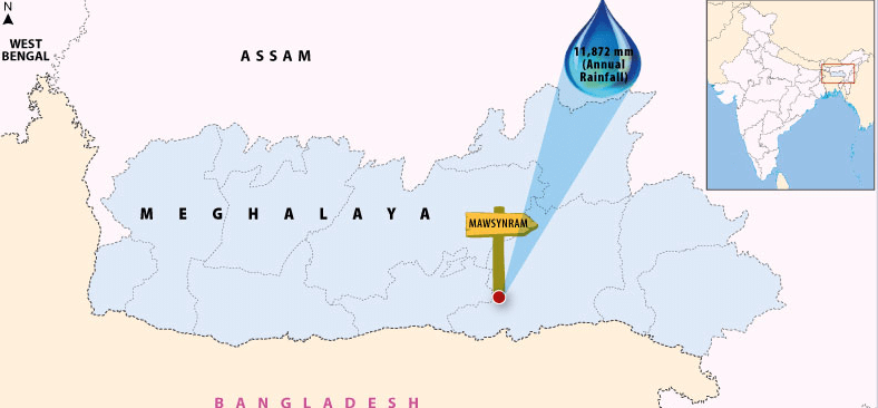
(i) Which one of the following places receives the highest rainfall in the world?
(a) Silchar
(b) Mawsynram
(c) Cherrapunji
(d) Guwahati
Ans: (b) Mawsynram
Mawsynram, located in the state of Meghalaya, India, is known for receiving the highest rainfall in the world.
(ii) The wind blowing in the northern plains in summers is known as:
(a) Kaal Baisakhi
(b) Loo
(c) Trade Winds
(d) None of the above
Ans: (b) Loo
The Loo is a hot, dry wind blowing across the northern plains of India during the summer months
(iii) Monsoon arrives in India approximately in:
(a) Early May
(b) Early July
(c) Early June
(d) Early August
Ans: (c) Early June
Monsoon generally arrives in India around early June, bringing much-needed rain to various parts of the country.
(iv) Which one of the following characterises the cold-weather season in India?
(a) Warm days and warm nights
(b) Warm days and cold nights
(c) Cool days and cold nights
(d) Cold days and warm nights
Ans: (b) Warm days and cold nights
The cold-weather season is characterized by warm days and cold nights, as daytime temperatures are more comfortable compared to the significantly colder nighttime temperatures.
Q2. Answer the following questions briefly.
(i) What are the controls affecting the climate of India?
Ans: The climate of India is influenced by six main factors:
- Latitude: The Tropic of Cancer runs through India, dividing it into tropical and subtropical regions. This affects the overall climate.
- Altitude: The northern mountains, averaging 6,000 meters, block cold winds from Central Asia, resulting in milder winters.
- Pressure and Winds: Weather patterns are shaped by atmospheric pressure, surface winds, and upper air circulation, including cyclonic disturbances.
- Distance from the Sea: Coastal areas experience moderated climates, while areas further inland face extreme temperatures
- Ocean Currents: These currents, along with onshore winds, significantly impact coastal climates, warming or cooling them based on the current’s temperature.
- Relief Features: Mountains can block winds and create rain shadows, leading to dry areas on the leeward side.
(ii) Why does India have a monsoon type of climate?
Ans: India has a monsoon type of climate due to the influence of monsoon winds, which primarily operate between 20° North and 20° South.
- The climate is characterised by distinct seasonal changes.
- It features both tropical and subtropical characteristics.
- Mountain ranges, like the Himalayas, block cold winds from Central Asia, resulting in milder winters.
- Weather patterns are influenced by: Pressure and surface winds, Upper air circulation, Western cyclonic disturbances and tropical cyclones.
(iii) Which part of India does experience the highest diurnal range of temperature and why?
Ans: The Indian desert, located in the north-western part of India, experiences the highest diurnal range of temperature. This is due to the following reasons:
- The sand in the desert heats up quickly during the day.
- At night, the sand cools down rapidly.
- For example, daytime temperatures can reach up to 50°C, while nighttime temperatures may drop to around 15°C.
(iv) Which winds account for rainfall along the Malabar Coast?
Ans: Malabar Coast gets rains from South-West Monsoon Winds.
(v) Define monsoons. What do you understand by “break” in monsoon?
Ans: Monsoons are a significant wind system that affects large climatic areas, reversing direction with the seasons. They are characterized by:
- Seasonal Changes: Monsoons bring distinct wet and dry periods, particularly during the rainy season.
- Breaks in Rainfall: The term “break” refers to intervals of dry weather amidst the rainy season, where rainfall occurs only for a few days at a time.
- Monsoon Trough Movement: The position of the monsoon trough influences rainfall distribution. When it is over the plains, rainfall is abundant; when it shifts towards the Himalayas, dry spells occur in the plains.
- Impact on Regions: Heavy rains can lead to significant downpours in mountainous areas, while plains may experience prolonged dry periods.
(vi) Why is the monsoon considered a unifying bond?
Ans: The monsoon is considered a unifying bond because:
- The monsoon of India is highly influenced by its flora and fauna.
- These monsoon winds provide the water for agricultural activities.
- Most of the festivals in India that are related to the agricultural cycle may be known by different names in different parts of the country, but the monsoon decides their celebration.
- The river valleys which carry this water also unite as a single river valley unit.
Q3. Why does the rainfall decrease from the east to the west in Northern India?
Ans: The rainfall decreases from the east to the west in Northern India because of the following reason:
- The low-pressure area in India lies in the northwest, towards which the South West Monsoon winds are attracted.
- After depositing moisture in south India, the Bay of Bengal branch of the South West Monsoons strikes the Khasi-Garo Hills.
- After causing heavy rainfall on the windward slopes, these winds turn westwards because of the presence of the lofty Himalayas.
- These winds then keep depositing rainfall, they go up the Ganga Valley towards the low-pressure area.
Q4. Give reasons as to why.
(i) Seasonal reversal of wind direction takes place over the Indian subcontinent.
Ans: The seasonal reversal of wind direction over the Indian subcontinent happens because:
- Winter Pressure: In winter, a high-pressure area forms north of the Himalayas, causing cold winds to blow towards low-pressure areas over the oceans.
- Summer Low Pressure: In summer, a low-pressure area develops over interior Asia and northwestern India, reversing the wind direction.
- Wind Movement: Air moves from the high-pressure zone over the southern Indian Ocean, flowing southeast, crossing the equator, and turning towards the low-pressure areas in India.
- Monsoon Winds: These winds, known as the Southwest Monsoon winds, carry moisture and bring widespread rainfall to India.
(ii) The bulk of rainfall in India is concentrated over a few months.
Ans: The monsoon in India starts in early June and quickly spreads across the country by mid-July. Most of the rainfall occurs during a few months, primarily from June to August.
- The windward side of the Western Ghats receives over 250 cm of rain.
- Regions like the Deccan Plateau and parts of Madhya Pradesh also get rainfall, despite being in the rain shadow area.
- The north-eastern part of India experiences the highest rainfall, with Mawsynram in Meghalaya being the wettest place on Earth.
- Rainfall in the Ganga valley decreases from east to west, while Rajasthan and parts of Gujarat receive very little rain.
(iii) The Tamil Nadu coast receives winter rainfall.
Ans: The Tamil Nadu coast receives winter rainfall because of the movement of low-pressure conditions to the Bay of Bengal.
(iv) The delta region of the eastern coast is frequently struck by cyclones.
Ans: The Bay of Bengal is a hotspot for pressure changes, leading to a high likelihood of cyclone formation. Consequently, the delta region along the eastern coast often experiences cyclones.
- In the second half of October, temperatures in northern India drop significantly.
- Low-pressure areas over northwestern India shift to the Bay of Bengal by early November.
- This shift triggers cyclonic depressions originating from the Andaman Sea.
- The densely populated deltas of the Godavari, Krishna, and Kaveri rivers frequently suffer from cyclone damage.
- Occasionally, cyclones also reach the coasts of Odisha, West Bengal, and Bangladesh.
(v) Parts of Rajasthan, Gujarat and the leeward side of the Western Ghats are drought-prone.
Ans: Mountains play an important role in the distribution of rainfall in India. The moisture-laden winds (South West Monsoons) cause heavy rain on the windward slopes of the Western Ghats and Khasi-Garo hills. When winds cross over mountains, they lose most of their moisture on the windward side (the side facing the wind), resulting in less rainfall on the leeward side (the side sheltered from the wind). This dry area on the leeward side, which gets very little rain, is often drought-prone. Rajasthan is an example of such a region; it lies in the rain shadow of the Aravalli Hills, meaning it receives significantly less rainfall compared to areas on the windward side of the hills.
Q5. Describe the regional variations in the climatic conditions of India with the help of suitable examples.
Ans: There is regional variation in the climatic conditions of India. Temperature and Precipitation vary from place to place and season to season.
- During the summer season, the temperature rises up to 50°C in parts of Rajasthan, whereas it may be around 20°C in Pahalgam in Kashmir.
- During the winter season at night, the temperature in Drass in Kashmir may be minus 45°C, whereas in Thiruvananthapuram in Kerala may have a temperature of 20°C.
- In the Andaman Islands, the difference between the temperatures of day and night may be hardly 7° – 8°C.
- Most parts of India receive rainfall from June – September, whereas some parts like the Tamil Nadu coast get a large portion of its rain during October and November.
Q6. Give an account of weather conditions and characteristics of the cold season.
Ans: The cold weather season in northern India has several distinct features:
- Duration: It starts in mid-November and lasts until February.
- Coldest Months: December and January are the coldest.
- Temperature: In the northern plains, temperatures range from 10°C to 15°C, while in Chennai, it is warmer at 24°C to 25°C.
- Day and Night: Days are generally warm, but nights can be quite cold.
- Winter Rainfall: Known locally as mahawat, this rainfall is crucial for the rabi crop, despite being small in quantity.
Q7. Give the characteristics and effects of the monsoon rainfall in India.
Ans: Characteristics of the monsoon rainfall in India:
- The duration of the monsoon varies from 100 to 120 days from early June to mid-September.
- The normal rainfall suddenly increases, around the time of its arrival and continues regularly for several days. This is called the ‘burst’ of the monsoon.
- The monsoon arrives at the southern tip of the Indian Peninsular generally by the first week of June.
Effects of the monsoon rainfall in India:
- Agriculture in India largely depends on Indian monsoons for water. Late, Low, or excessive rains have a negative impact on crops.
- Due to the uneven distribution of rainfall across the country, there are few places that are drought-prone and few are flood-affected.
- The monsoon provides India with a diverse climatic pattern. Hence, despite the presence of great regional variations, it has a unifying influence on the country and its people.
Map Skills
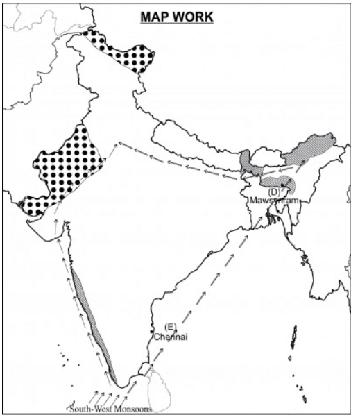
Q. On an outline map of India, show the following.
(i) Areas receiving rainfall over 400 cm.
(ii) Areas receiving less than 20 cm of rainfall.
(iii) The direction of the southwest monsoon over India.
Ans:
(i) The Western Coast and North Eastern India receive rainfall over 400 cm. Mawsynram and Cherrapunji in Meghalaya are known for receiving maximum rainfall in the world. The Andaman Islands and Lakshadweep Islands are also known to receive annual rainfall above 400 cm.
(ii) The parts of Northern Kashmir, Western Rajasthan, Deccan Plateau and Punjab are known to be the areas that receive scanty rainfall that is less than 20 cm. In the Northern part of India, rainfall decreases toward the west, while in the peninsular region except for Tamil Nadu, the rainfall decreases eastwards.
(iii) In early June, a low-pressure area over northern India attracts southeast trade winds from the southern hemisphere. These winds blow southwesterly into India, bringing moisture and abundant rainfall. Moving at about 30 km per hour, the southwest monsoon signals the start of the rainy season, transforming the weather across the country.